
TouchGraphics is a company that creates various kinds of tactile and braille maps and materials for people who are blind or low-vision. Based on significant research, these maps utilize braille and raised lettering and symbols as well as color-contrast to convey various kinds of information in ways that are accessible to people who are blind or low-vision.
As part of the Accessible Station Lab pilot, TouchGraphics has created two different tactile signs:
- Tactile R Line Maps: list the stations along the R line from Jay St-MetroTech in both directions in high-contrast lettering and braille.
- Interactive Tactile Station Environment Map: this touch-activated map provides visual, audio, and tactile information to help customers get around the station.
These maps aim to make the information usable by everyone, following the principle of universal design.
Tactile R Line Map
On the R platform there are two new tactile maps on the first column at the bottom of the stairs leading down from the main mezzanine:
- The Bay Ridge-bound section of the R line is on the side of the column facing the stairway
- The Manhattan and Queens-bound section of the R line is on the opposing side of the column
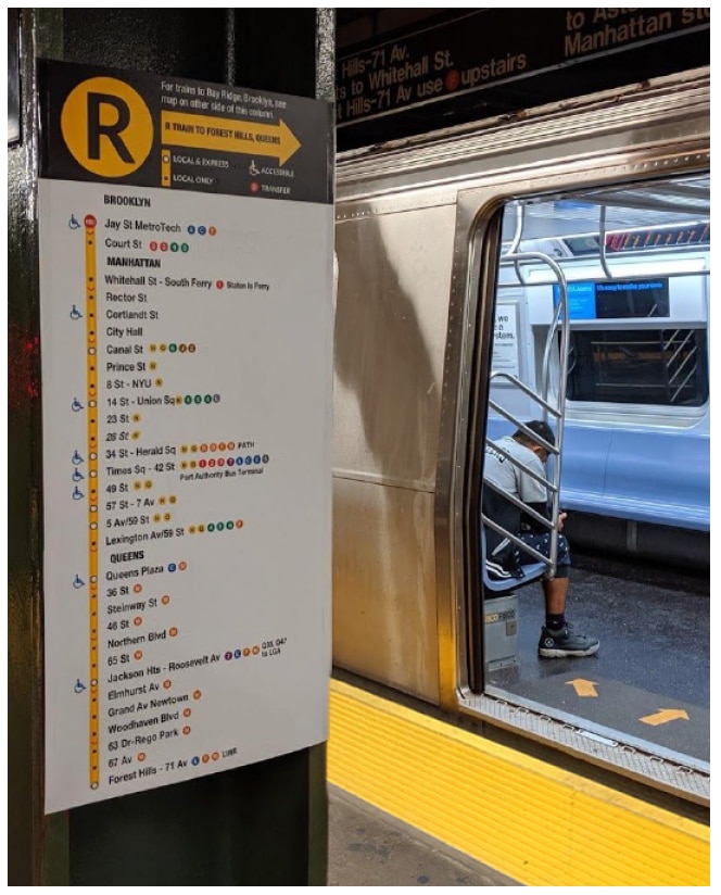
These maps:
- Display clear information about stops on the R line in bright, contrasting colors that are especially useful for low-vision riders.
- Display the same information using braille and tactile symbols for blind riders.
- Highlight transfers and accessible stations, important travel information for all subway riders.
The braille text, bright, contrasting colors, and tactile symbols make these signs especially useful for blind or low-vision riders navigating the subway system, but we hope this new map will be useful to everyone who wants to better understand service on this subway line!
To learn more about TouchGraphics, visit http://touchgraphics.com/.
Interactive Tactile Station Environment Map
This interactive map:
- orients users to the main mezzanine at Jay St-MetroTech in tactile, visual, and audio formats.
- highlights the tactile guideway we’ve created on the station floor with raised blue tiles, which is designed to help blind or low-vision riders navigate their way through the station.
- helps riders know what to expect along their trip through the mezzanine.
- shows the location of the station booth, stairways and elevators to each platform, and the fare array – information that is useful for any subway rider.
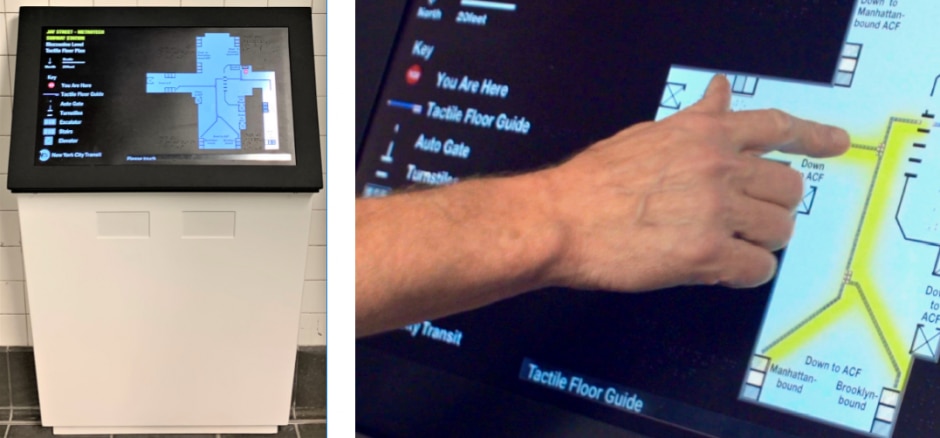
Here’s how it works:
- The map uses tactile symbols shown in a key on the left. Touch a feature, then touch anywhere on the map to activates audio information about that feature.
- Touch once for basic information.
- Touch again for more details, such as the direction of travel on the platform that a specific set of stairs serves.
By providing information in text, tactile, and audio formats, the Touch Graphics interactive map aims to make the information usable by everyone, following the principle of universal design. Touch the map and see how it can help orient you to the station!
Tell Us What You Think!
If you have feedback, you can use our web form and select Subways and Compliment (even if your feedback isn't positive--we want to hear it all!) from the drop down menus. Then select A Station and choose Accessible Station Lab, and tell us in the comment field which feature or features you tested and what you think. You can also call 511 and tell us what you think.